CE-603 (A) · Water Resource Engineering/Unsolved PYQ Paper
CE-603-A Water Resources Engineering - May 2022 Question Paper
Under each question, How to answer lists the points an answer should cover, outlined by CampusPrep from the syllabus. Check the details against your textbook.
-
7 MarksaExplain free flooding, border flooding and check flooding in brief with the help of neat sketches.
How to answer
- Define free flooding, border flooding and check flooding
- Explain field layout and flow conditions for each
- Neat sketches showing strips, borders, checks and flow direction
- Suitability / comparison of methods
-
7 MarksbDetermine the time required to irrigate a strip of land of 0.04 hectares in area from a tube well with a discharge of 0.02 cumec. The infiltration capacity of the soil may be taken as 5 cm/hr, and the average depth of flow on the field as 10 cm. Also determine the maximum area that can be irrigated from this tube well.
How to answer
- Compute volume of water required from area and depth/infiltration
- Use discharge to find time $t = Volume/Q$
- Apply condition for maximum area from infiltration capacity and flow depth
- Calculate time and maximum area with units
-
7 MarksaA certain crop is grown in an area of 3000 hectares, which is fed by a canal system. The data pertaining to irrigation are as follows: Field capacity of soil = 26%, Optimum moisture = 12%, Permanent wilting point = 10%, Effective depth of root zone = 80 cm, Apparent relative density of soil = 1.4. If the frequency of irrigation is 10 days and the overall irrigation efficiency is 22%. Find:
- i)Daily consumptive use
- ii)Water discharge in m³/s required in the canal feeding the area.
How to answer
- Compute available moisture depth from field capacity, optimum/PWP, root depth and density
- Divide by frequency to get daily consumptive use
- Compute total water requirement using efficiency
- Convert volume per day to canal discharge in $m^3/s$
-
7 MarksbExplain the classification of irrigation canals based on:
- i)Function of canal
- ii)Discharge and relative importance in a given network of canals.
How to answer
- Define classification by function: main, branch, distributary, minor, watercourse
- Explain each function with hierarchy
- Define classification by discharge/importance: major, medium, minor etc.
- Relate discharge range to importance in network
-
7 MarksaDefine Lacey's regimes channels. Write any four drawbacks of Lacey's theory.
How to answer
- Define Lacey's regime channel and regime conditions
- State silt factor and regime equations in brief
- List any four drawbacks/limitations of Lacey's theory
- Concluding remark on applicability
-
7 MarksbDesign a regime channel for a discharge of 35 m³/s with a silt factor of 0.9 by Lacey's theory. Taking side slopes as 1H:2V.
How to answer
- Compute Lacey's regime velocity, hydraulic radius and area from $Q$ and $f$
- Determine wetted perimeter and depth
- Apply side slopes 1H:2V to get bed width
- Check longitudinal slope using Lacey's slope formula
-
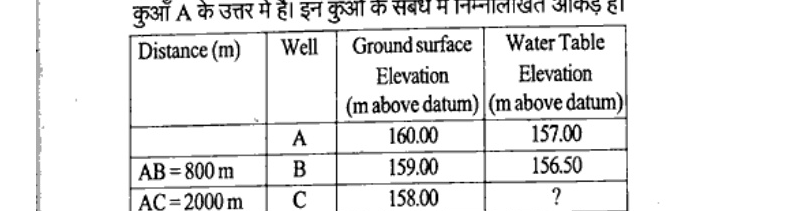
7 MarksaAn extensive aquifer is known to have a groundwater flow in N30°E direction. Three wells A, B and C are drilled to tap this aquifer. The well B is to east of A and the well C is to north of A. The following are the data regarding these wells. Estimate the elevation of water table at well C when the wells are not pumping.
How to answer
- Use three-well method and flow direction N30°E
- Compute hydraulic gradient from wells A and B
- Project gradient to line through C to find head at C
- Convert head to water table elevation at C
-
7 MarksbIn a certain alluvial basin of 100 km², 90 mm³ of ground water was pumped in a year and the ground water table dropped by about 5 m during the year. Assuming no replenishment, estimate the specific yield of the aquifer. If the retention is 12%, what is the porosity of the soil?
How to answer
- Compute volume pumped per unit area = drop * specific yield
- Estimate specific yield from $Volume = A*delta_h*S_y$
- Use porosity = specific yield + retention
- Calculate porosity with retention 12%
-
7 MarksaA small watershed consists of 2 km² of forest area (c = 0.1), 1.2 km² of cultivated area (c = 0.2) and 1 km² under grass cover (c = 0.35). A water course falls by 20 m in a length of 2 km. The IDF relation for the area may be taken as i = 80 T$^{0.2}$/(t + 12)$^{0.5}$. Estimate the peak rate of runoff for a 25-year frequency.
How to answer
- Compute weighted runoff coefficient from land uses
- Estimate time of concentration from fall and length
- Compute rainfall intensity from IDF for T=25 years
- Apply rational formula $Q = C*i*A$ for peak runoff
-
7 MarksbOn the basis of hydrograph studies explain in brief about perennial and ephemeral stream with suitable diagrams.
How to answer
- Define perennial and ephemeral streams from hydrograph/baseflow
- Explain position of water table relative to stream bed
- Draw hydrographs/stream sections for both types
- Mention seasonal behaviour and examples
-
7 MarksaThe rates of rainfall for the successive 30 min period of a 3-hour storm are : 1.6, 3.6, 5.0, 2.8, 2.2, 1.0 cm/hr. The corresponding surface runoff is estimated to be 3.6 cm. Establish the $\varphi$-index. Also determine the W-index.
How to answer
- Compute total rainfall depth from 30-min intensities
- Use runoff 3.6 cm to set up phi-index trial
- Exclude periods with rainfall <= phi to find phi-index
- Compute W-index including initial losses
-
7 MarksbExplain in brief about the analytical methods for determination of lake evaporation.
How to answer
- Define lake evaporation and need for analytical methods
- Explain water budget, energy budget and mass transfer methods
- Give governing equations and data required
- Mention limitations/assumptions
-
7 MarksaExplain Arithmetic mean method and Thiessen polygon method for calculation of average depth of precipitation over a catchment.
How to answer
- Define average precipitation over catchment
- Explain arithmetic mean: formula and when applicable
- Explain Thiessen polygon: construction, weights and formula
- Compare merits/demerits with diagram
-
7 MarksbExplain Muskingum method of channel routing and steps involved in it.
How to answer
- Define channel routing and Muskingum storage equation $S=K[xI+(1-x)Q]$
- Explain parameters K and x and continuity equation
- Give steps: calibration, routing coefficients C0,C1,C2, routing
- Mention assumptions and applications
-
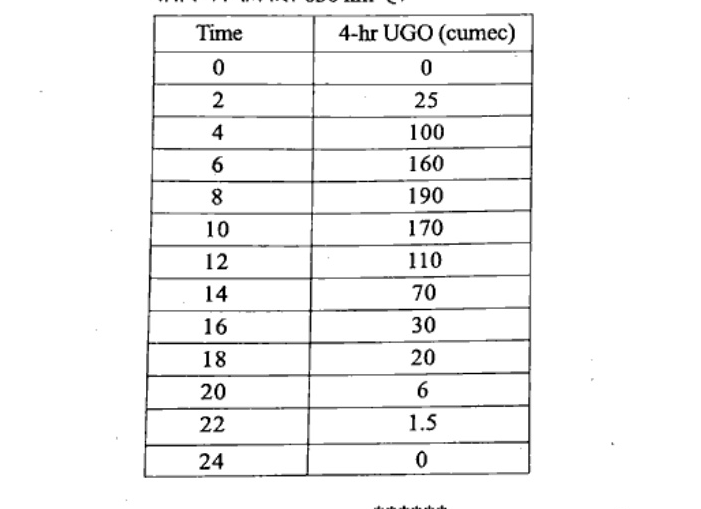
14 MarksThe ordinates of a 4-hour unit hydrograph for a particular basin are given below. Determine the ordinates of the S-curve hydrograph and therefrom the ordinates of the 2-hour unit hydrograph and plot them, area of the basin is 630 km².
How to answer
- Check volume of 4-hr UH for 630 km² to get 1 cm depth
- Build S-curve by lagging 4-hr UH by 4 hr and summing
- Derive 2-hr UH as difference of S-curves lagged by 2 hr multiplied by 4/2
- Tabulate ordinates and plot S-curve and 2-hr UH
Go to where you left off?
Quick Add to Notes
Save questions, your own notes and screenshots into notes filed by unit. It takes a free account.
Create free accountHave an account? Log in
Notes Panel